Dusky Woodswallows and other aspects of Newline
This is really a schizophrenic post as it will cover two different (albeit related) things. I guess I'll have to keep taking the medication!
The background is that I have been looking at the Canberra Ornithologists Group grid system for reporting bird sightings. One of the difficulties of this is that in some cases well-known birding spots are cut into two (or more) chunks of very similar habitat by the arbitrary nature of latitudes and longitudes. One of these spots is an area to the East of Canberra Airport which I have taken to calling Newline Paddocks as it is paddocks, and close to, but distinct from, Newline Quarry. I decided to collect data from both parts of the site today to see what sense this split made expecting the answer to be 'none'.
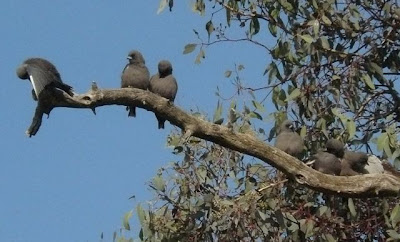
On first starting my birding foray I was struck by the number of Dusky Woodswallows still present and took a few images. The first shows a row of little cuties sitting on a branch: my guess is tht there were 30+ birds in the whole flock.
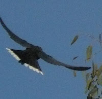 The other two images are clipped from bracketed images which serendipitously caught nice flight shots.


Moving on to the main business, the attached extract from Google Earth shows the paddock in question (outlined in dashed yellow) and the location of the grid line.
Doing a rough measure of the boundaries on Google Earth and multiplying the result the areas of the two areas of paddock within the two grid cells are M14, 1.65Ha and N14 7.0Ha. Allowing some time for sorting out where the grid line went I estimate I spent about 20 minutes in M14 and 80 minutes in N14 which is reasonably close to the correct ratio.
In total I wrote down 18 species for the day. 8 of these were common to both sites and thus 10 species were only found in one square (6 in N14 and 4 in M14). It was interesting that none of the Newline specials were found in either grid square (and a couple of other members of COG have subsequently commented about similar experiences).
It is impossible to quantify, from a sample of 1 set of observations, how significant such differences are. The exercise did provide some interesting anecdotal evidence.
The background is that I have been looking at the Canberra Ornithologists Group grid system for reporting bird sightings. One of the difficulties of this is that in some cases well-known birding spots are cut into two (or more) chunks of very similar habitat by the arbitrary nature of latitudes and longitudes. One of these spots is an area to the East of Canberra Airport which I have taken to calling Newline Paddocks as it is paddocks, and close to, but distinct from, Newline Quarry. I decided to collect data from both parts of the site today to see what sense this split made expecting the answer to be 'none'.
On first starting my birding foray I was struck by the number of Dusky Woodswallows still present and took a few images. The first shows a row of little cuties sitting on a branch: my guess is tht there were 30+ birds in the whole flock.


Moving on to the main business, the attached extract from Google Earth shows the paddock in question (outlined in dashed yellow) and the location of the grid line.
Doing a rough measure of the boundaries on Google Earth and multiplying the result the areas of the two areas of paddock within the two grid cells are M14, 1.65Ha and N14 7.0Ha. Allowing some time for sorting out where the grid line went I estimate I spent about 20 minutes in M14 and 80 minutes in N14 which is reasonably close to the correct ratio.
In total I wrote down 18 species for the day. 8 of these were common to both sites and thus 10 species were only found in one square (6 in N14 and 4 in M14). It was interesting that none of the Newline specials were found in either grid square (and a couple of other members of COG have subsequently commented about similar experiences).
| Atlas code | Common name | M14 | N14 |
| 43 | Crested Pigeon | 1 | |
| 269 | Sulphur-crested Cockatoo | 2 | |
| 273 | Galah | 2 | |
| 282 | Crimson Rosella | 4 | 5 |
| 288 | Eastern Rosella | 1 | |
| 295 | Red-rumped Parrot | 6 | 2 |
| 357 | Welcome Swallow | 1 | |
| 364 | Willie Wagtail | 1 | |
| 424 | Black-faced Cuckoo-shrike | 2 | 1 |
| 529 | Superb Fairy-wren | 3 | 24 |
| 547 | Dusky Woodswallow | 24 | 29 |
| 565 | Spotted Pardalote | 2 | |
| 625 | White-plumed Honeyeater | 2 | 6 |
| 638 | Red Wattlebird | 2 | |
| 705 | Australian Magpie | 3 | |
| 930 | Australian Raven | 1 | |
| 976 | Striated Pardalote | 2 | 3 |
| 999 | Common Starling | 1 | 2 |
It is impossible to quantify, from a sample of 1 set of observations, how significant such differences are. The exercise did provide some interesting anecdotal evidence.
- The flock of Dusky Woodswallows were first detected in the SW corner of the paddock (M14) where they stayed until I had nearly completed my search in N14 at which point they all flew into N14 to hunt a flock of insects.
- If an analyst merely looked at the data without the location name they might conclude that there were 53 Dusky Woodswallows observed that day rather than it basically being the same birds plus a few extras seen in N14.
- Had I done the search in the opposite order the birds would not have been counted in either site (unless I put in a 3rd incidental record to cover the flock being seen in N14 while I was in M14).
- There were 6 Red-rumped Parrots in Newline Paddocks during my period of observations. At one point 2 of them flew into grid N14 while I was counting in that grid cell and were also counted there. For this species such an observation is probably not important but if it had been 2 Brown Treecreepers counted in both grid cells the suggestion of 4 birds rather than two could lead to some very misleading thoughts about successful breeding.
- It was difficult to keep track of exactly where the boundary was, despite having placed some tags of surveyor tape on the fences at the appropriate spots. In effect I used the point where the creek crossed the Western fence and some containers on the Southern edge as landmarks. It was also helpful that a large concrete bunker was about 20m inside M14: this was visible from everywhere on the boundary (whereas the topography of the block meant that the Southern bounadry was not not visible from the lower point of the area..
- are very difficult to operationalise as the boundary is not visible "on the ground";
- have no biological relevance(birds fly back and forth); and
- through counting the same birds at different times in different grid cells, make it possible to generate misleading information.


Comments